Showing posts with label Travel. Show all posts

The Sunken City on Kekova Island

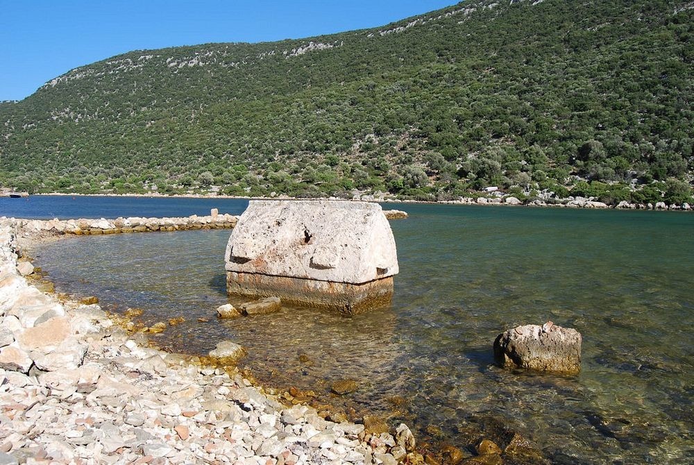
The ancient Lycian city of Simena, often referred to as Kekova-Simena, once straddled the long and narrow island of Kekova in the Mediterranean Sea near the Turkish coastline. In the olden times, Simena was a small fishing village and was later an outpost of the Knights of Rhodes.

Part of the city lies on the mainland, where today stands the charming fishing village of Kaleköy. The mixture of ancient, medieval and modern history on Kaleköy makes it one of the of the most visited places in Turkey today. Worth seeing here is the well-preserved castle built by the Knights of Rhodes, and the Lycian necropolis overlooking the sea and surrounded by ancient olive trees. Across the bay, on Kekova Island, lies Simena’s other half. This part of the city today lies half-submerged in the waters. The land slipped into the ocean when a terrible earthquake struck Turkey in the 2nd century. Half of the houses, now in ruins, are submerged with staircases descending into the water. Some of foundations of buildings and the ancient harbor are totally beneath the water’s surface.

kekova-sunken-city-3

Photo credit: Alessandra Kocman/Flickr

The entire Kekova region was declared a specially protected area in 1990 by Turkish government, and subsequently diving and swimming here was prohibited. Although the prohibition was lifted in later years, the area where the sunken city is is still restricted.

kekova-sunken-city-1

Photo credit: Vladimer Shioshvili/Flickr

kekova-sunken-city-2

Photo credit: Chris Walsh/Flickr

kekova-sunken-city-4

Photo credit: Alessandra Kocman/Flickr

kekova-sunken-city-6

Photo credit: Massimiliano Giani/Flickr

kekova-sunken-city-7

Photo credit: Bengt Flemark/Flickr

kekova-sunken-city-5

Photo credit: JJ Hall/Flickr

Sources: www.traveltofethiye.co.uk / lycianturkey.com / Wikipedia

Subscribe to our Newsletter and get articles like this delieverd straight to your inbox

Bozouls: A French Town Perched Above A ‘Hole’

Trou de Bozouls, or “the hole of Bozouls”, is a large horseshoe-shaped canyon located near the commune of Bozouls in the Aveyron department in southern France. The meander was dug out in the limestone by the erosive action of running water of the Dourdou river as it flows through the large limestone plateau of Causse Comtal in Massif Central. The canyon is 400 meters across and more than 100 meters deep. The most striking feature of this natural monument is the town of Bozouls perched right at the edge of the bend. Bozouls's geographical location, high above one of the bends of the Dourdou river, gives the town a naturally defensive stronghold.

The Massif Central region, consisting of mountains and plateaus, and covering approximately 15 percent of the entire country of France, began forming some 600 million years ago when hercynian folding resulted in the thrusting up of great mountain ranges. New mountains kept forming as recently as 60 million years go. About two million years, a succession of ice ages caused glaciers to advance and recede, causing rivers rise and fall. The landscape that we see today is the result of this.

trou-de-bozouls-4

Photo credit: syl.lemouzy/Flickr

trou-de-bozouls-9

Photo credit: Mairie-bozouls/Wikimedia

trou-de-bozouls-2

Photo credit: syl.lemouzy/Flickr

trou-de-bozouls-3

Photo credit: syl.lemouzy/Flickr

trou-de-bozouls-1

Photo credit: syl.lemouzy/Flickr

trou-de-bozouls-5

Photo credit: syl.lemouzy/Flickr

trou-de-bozouls-6

Photo credit: Mya Klips/Flickr

trou-de-bozouls-7

Photo credit: Sonia Thuery/Flickr

trou-de-bozouls-8

Photo credit: INRA DIST/Flickr

Sources: www.experiencemyfrance.com / Wikipedia

Subscribe to our Newsletter and get articles like this delieverd straight to your inbox

The Hell’s Bells of Cenote Zapote

Deep below the surface, inside the water filled caverns of Cenote Zapote in Mexico's Yucatan Peninsula, stalactites grow into strange shapes. Instead of their typical pointed tips, the stalactites hanging down from the roofs at Cenote Zapote have a blown out mouth like that of a bell. They have been called variously as hell’s bells, elephant feet, shower heads or trumpets.

The phenomenon of hell’s bell is not understood. How were they formed, or why there are no other dive sites where these structures can be found? Hell’s bell is believed to be a kind of folia formation, that are usually found just below the water line. The bells could have developed out of folia as the water table changed since the last ice age. But the mechanism of folia formation itself is not fully understood and is the subject of an ongoing debate.

hells-bells-zapote-cenote-3

Photo credit: inspiredtodive.com

Cenote Zapote is located west of Puerto Morelos in Mexico's Yucatan Peninsula. The sinkhole took its name from the Sapote trees growing around.

The hell’s bell formations are located at a depth of about 30 meters.

hells-bells-zapote-cenote-1

Photo credit: inspiredtodive.com

hells-bells-zapote-cenote-2

Photo credit: inspiredtodive.com

hells-bells-zapote-cenote-4

Photo credit: inspiredtodive.com

Sources: Inspired to Dive / www.sciencedirect.com / Diving-caves.com

Subscribe to our Newsletter and get articles like this delieverd straight to your inbox

Tokyo’s Iconic Shibuya Crossing

It’s hard to believe that in a mega metropolis like Tokyo, one of the biggest attraction is not a tower or a statue or a museum or a park, but a pedestrian crossing. You might have already seen it in news broadcasts, in movies and in television shows. It appeared in Lost in Translation, The Fast and the Furious: Tokyo Drift, and Resident Evil: Afterlife and Resident Evil: Retribution. The traffic intersection in itself is nothing spectacular —a ten-lane crossing in the middle of Tokyo’s fashionable shopping district surrounded by neon signs and giant billboards screaming with advertisements. But what happens here at the massive Shibuya crossing —located just outside the Shibuya station’s Hachikō exit —once the traffic light turns red, is worth seeing.

shibuya-crossing-15

Photo credit: Shibuya246/Flickr

Like many crossings throughout Japan, when the lights turn red at this busy junction, they all turn red at the same time in every direction. Car traffic stops completely and the mass of pedestrians waiting on the four corners surge into the intersection from all sides, “like marbles spilling out of a box,” as one writer puts it. They all meet in the middle in a frantic mess, but instead of bumping into each other, they skillfully weave and dart around each other’s bodies avoiding collision, the same way cards slide seamlessly past each other during shuffle in the hands of an expert Las Vegas dealer. This strange courtesy, the politeness, the organized chaos, fascinates everybody who isn’t Japanese.

“When you watch footage of The Scramble, you can’t help but wonder what holds this system together. How do people remain so well-behaved?” wonders writer Aaron Gilbreath.

The intersection stays open for pedestrians for nearly a minute, and then it stops. The traffic light changes and once again vehicles get the right of way. While the vehicles are moving, each corner of the intersection steadily fills up with people. There are shoppers, commuters, school girls, teenagers, and punks with died blue hair, all waiting for their turn. Then the crosswalk lights turn green, and “the mayhem starts all over again.”


The Shibuya crossing is said to be the busiest intersection in the world. At peak times, as many as 2,500 people cross the streets with a single change of a traffic signal, and over 2 million in a single day.

Shibuya’s unusual crossing is also known as a scramble intersection, as 'X' Crossing in the UK, and as diagonal crossing in the US. It’s also called the Barnes Dance, named after traffic engineer Henry Barnes, who popularized it in the 1940s, when he was serving as street commissioner in Denver. The dance got its name when reporter wrote that the crossings made the people so happy that they danced their way across the streets.

The scramble intersection came to Japan in 1969, and while the US and Canada slowly got rid of the system for being inefficient, it grew steadily in numbers in Japan. Today, there are more than 300 scramble crossing in the country.

It is said that a visit to Tokyo is incomplete without experiencing the Shibuya crossing. But if fighting your way through the havoc in the center of the intersection is not your cup of tea, you can watch it from a distance. The hypnotic view can be best observed from the second-story window of Starbucks on the building across the street, on the crossing's north side.

Related Reading: Magic Roundabout: The Most Confusing Traffic Junction

shibuya-crossing-3

Photo credit: Michael McDonough/Flickr

shibuya-crossing-2

Photo credit: Aldas Kirvaitis/Flickr

shibuya-crossing-11

Photo credit: Dick Thomas Johnson/Flickr

shibuya-crossing-4

Photo credit: Matthew Kenwrick/Flickr

shibuya-crossing-5

Photo credit: Candida.Performa/Flickr

shibuya-crossing-10

Photo credit: Yoshikazu TAKADA/Flickr

shibuya-crossing-6

Photo credit: Thomas/Flickr

shibuya-crossing-7

Photo credit: inefekt69/Flickr

shibuya-crossing-9

Photo credit: Yoshikazu TAKADA/Flickr

shibuya-crossing-12

Photo credit: Dick Thomas Johnson/Flickr

shibuya-crossing-14

Photo credit: Meow _ Bibi/Flickr

Sources: LA Times / Time.com / Japan Travel / Wikipedia

Subscribe to our Newsletter and get articles like this delieverd straight to your inbox

The Mounds of North America

The American heartland was once dotted by thousands of ceremonial and burial mounds. They occurred over a large area that stretched from the Great Lakes to the Gulf of Mexico and from the Mississippi River to the Appalachian Mountains. When Europeans first landed on America and found that even the natives had no knowledge of their origin, they thought that some lost civilization unrelated to the Native Americans were responsible for their creation, because they assumed that the natives were too uncivilized and too unsophisticated to create such lasting monuments. These mysterious architects came to be known simply as “mound builders”.

man-mound-2

Man Mound in Baraboo, Wisconsin. Photo credit: Ethan Brodsky

Speculations about this unknown civilization gave rise to many theories about ‘lost tribes from Israel that came to America and built the mounds, and even refugees from Atlantis. It’s now largely accepted that the mound builders were none other than ancestors of present day Native American tribes, but they lived so long ago that everything about them was forgotten.

Archaeological research indicates that the mounds were built by many different societies that lived in different periods of time that stretched from 3500 BC to about 1000 CE. Some of them were hunter-gatherers; others were farmers. The earthen mounds were built for different purposes and had different shapes and sizes, that ranged from flat-topped pyramids to conical or linear structures. Some were effigy mounds built to resemble shapes of animals and human figures. The most famous effigy mound is the Serpent Mound in southern Ohio, that resembles a coiled serpent more than 400 meters long. Another mound located in Baraboo, Wisconsin, is in the form of a man and measures 65 meters long.

It is estimated that over 75% of mounds were obliterated by farmers who regarded them as mere bumps in the field and obstacles to cultivation. One early Sauk County farmer was reported to have said: “We were rather irked by the large number of Indian mounds we had to plow down. There must have been at least 25 on our land….Some were shaped like animals and some like birds, and all were from three to five feet high...I suppose we should not have destroyed them. But they were then regarded merely as obstacles to cultivation, and everybody plowed them down."

The handful of mounds that remain today are protected, and listed on the National Register of Historic Places.

man-mound-1

Man Mound in Baraboo. www.wiscnews.com

bird-mound-1

“Bird Mound” on the south shore of Devil’s Lake, Wisconsin. Photo credit: Jared Kuschewski

serpent-mound-2

Serpent Mound in southern Ohio. Photo credit: Geocaching.com

serpent-mound-1

Serpent Mound in southern Ohio. Photo credit: Roy Luck/Flickr

grave-creek-mound-1

At 19 meters, the Grave Creek Mound in the Ohio River Valley in West Virginia is one of the largest conical-type burial mounds in the United States. Photo credit: Tim Kiser/Wikimedia

monks-mound-1

Monks Mound, near Collinsville, Illinois, is the largest Pre-Columbian earthwork in the Americas and the largest pyramid north of Mesoamerica. Photo credit: John Stagner/Flickr

monks-mound-2

Monks Mound, near Collinsville, Illinois. Photo credit: Jamie Kelly/Flickr

Sources: Sauk County History / Wikipedia / Encyclopedia.com

Subscribe to our Newsletter and get articles like this delieverd straight to your inbox

The Megaliths of Bada Valley

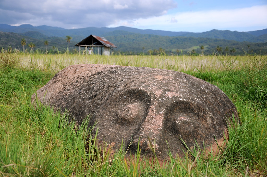
About 15 km to the south of Lore Lindu National Park on the Indonesian island of Sulawesi, in an area known as Bada valley, there are several carved megalith figures reminiscent of the Moai statues of Easter Island. The statues have straight bodies, oversized heads, round eyes, and a single line to define eyebrows, cheeks, and chin. Most of them stand alone half buried in the fields, obscured by long grasses. Others are toppled over in rivers. So far, more than four hundred carvings have been found in the area, but only about thirty are in the shape of humans figures.

Although the site was discovered more than a hundred years ago, very little is known about the ancient culture who made them. We don’t even know when these megaliths were carved. Proposed dates ranges from 1,000 years to 5,000 years ago.

Buffalo Megalith, Lore Lindu National Park

The megaliths were known to the locals for centuries before the Europeans found them. Based on the gender of the statues, identified from the clearly visible genitals, they have been given various names. There is a male named "Palindo" or "Entertainer", which is four meters tall and is the largest of the megaliths. Another called "Langke Bulawa" (or "Golden Bracelet") is a 1.8-meter-tall figure of a female. The villagers have weaved all sorts of tales around these characters. For instance, Palindo was said to be the court jester and was placed facing the ancient palace of the king. Its leaning stance is said to have come from the furious fights which raged between local tribes that disturbed his serenity. Then, there are less likable characters such as Tokala'ea, who was said to be a rapist turned to stone. The deep cut marks in the rock represent scars from knives. Another statue named Tadulako was once a trusted village protector but was turned to granite for stealing rice. And so on.

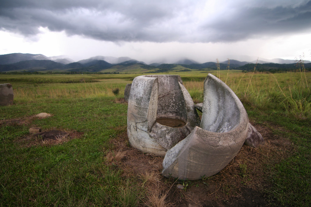
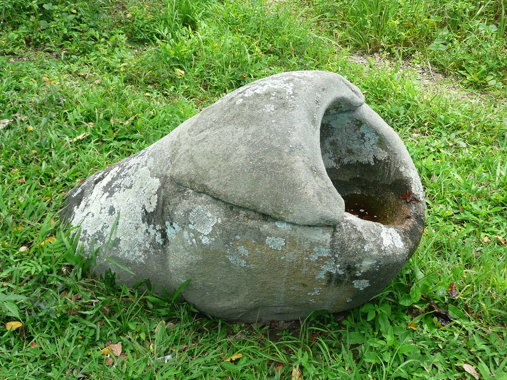
The statues are not the only megaliths in the area. As already mentioned, there are more than four hundred carvings in the area. Some of these, called kalamba, are circular stones resembling pots and cisterns. According to local folklore, they are ancient bathtubs used by kings. In reality, the kalambas might have been grain storage pots. Some of them even has heavy lids. Some kalambas are also accompanied by stone tablets with cavities, perhaps used for grinding food.

The strangest thing is, aside from these abandoned stone megaliths, no tools, remains of settlements or other evidence of the society that built them has ever been found.

bada-valley-megaliths-21

Photo credit: Magdalena & Thomas/Flickr

bada-valley-megaliths-22

Photo credit: Magdalena & Thomas/Flickr

bada-valley-megaliths-23

Photo credit: Magdalena & Thomas/Flickr

bada-valley-megaliths-24

Photo credit: Magdalena & Thomas/Flickr

bada-valley-megaliths-1

Photo credit: Incito Tour/Panoramio

bada-valley-megaliths-4

Photo credit: www.asiantrails.travel

Megalith in the Napu Valley

Megalith relics in Bada Valley (Jar megalith "Kalamba")

Sources: Nat Geo / Revelations of the Ancient World / www.megalithic.co.uk

Subscribe to our Newsletter and get articles like this delieverd straight to your inbox